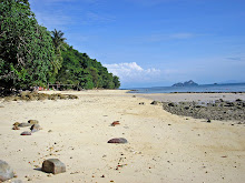
 "Survivor" country - Siobhan from Adelaide crosses this rickety bridge to the daytrip/camping area at the north end of Ao Son Beach on the west coast of Tarutao.
 Ko Tarutao is a big, mountainous rainforest-covered island very close to the Malaysian border in the Andaman. It is 100% National Park and has no other accommodation. The beaches are very nice. It is best known to travellers as one of the better places to get off the beaten track - but the general public would probably be more interested to know this was the site of Survivor Thailand, the second in the series from memory.
AREA MAP

ISLAND MAP (image Andman Island Hopping)
 Tarutao - there is a bigger image at:
http://www.andaman-island-hopping.com/islands/tarutao.htm
The main travellers’ destination is the Park Headquarters beach of Ao Pante Malaka in the north west of the island. This spacious and neatly laid out area has a visitors centre (get a free map and info sheet), small shop, clinic, good restaurant with prices LOWER than the average backpacker joint (30 baht small beers - crikey!) (UPDATE 2011 - apparently all National Parks are now alchohol free - crikey!!) and equipment sheds for road and other park maintenance. Accommodation is in spacious and pretty nice 1000 family and 600baht 2 person fan bungalows with bathroom, 400 baht long-house rooms which have 4 mattresses on the floor and an outside bathroom block (the men's looked okay to me but some German girls were less than whelmed by the ladies’). This section could be a bit noisy with timber walls between the rooms. There are 300baht 2 man tents (when I visited you provided bedding but later experience in the Surins saw bedding provided by National Parks - something to check). I think you can pitch your own tent for 100baht.
 This is a National Park tent - I think the deal is you can pitch it or your own tent anywhere along the beachfront or even on the sand - or cart it down to one of the more southern beaches mentioned later. Lots of space at Malaka - the closest bungalows are at least 50m back from the beach thru the casuarinas. Some freshwater showers are spaced just behind the sand.
There are also several open-sided but roofed areas which looked suitable for big group lectures - the park may get a fair few student and other group-visitors. Note there was wireless connection for laptops but not public-access computers. No ATMs or money-change facilities.
 The beach is a ripper, about 4 km long and backed by casuarinas and palms. Water was deep enough to swim not too far from shore even at lowest tide and was very clear, despite the proximity of Tarutao’s biggest stream Klong Pante Malaka which has the arrivals pier and is an okay place to hang out for some fishing and people watching when the Ko Lipe bound ferries and speedboats call in or some daytrip boats dock.
  Thai National Parks are very popular on weekends and public holidays. This Sunday shot saw 5 daytrip ferries moored at the pier for a few hours with about 400 visitors - real crowded at the pier, restaurant, shop, beach near the pier and at the info display in the reception cabana, but still uncrowded in the bungalow and remaining beach area.
Longtails are parked near the pier to shuttle visitors upstream to the Crocodile Caves - no muggers these days, but apparently the limestone formations are okay.
 I couldn’t find anyone who hadn’t gone or wanted to go to share a longtail to the cave (450baht return) - so I didn’t bother. Take your torch or rent one from the store.
 You can also charter a longtail to take you around to Ao Rusi in the NE of the island - where the printing "Crocodile Cave" is on the above island map (1100baht return) - which has the best snorkelling in the area. I gave that a miss to pique my online stalker Fiona who is always giving me hell for not checking the snorkelling, but I’ve since read that this was where they shot Survivor Thailand, which certainly looked an interesting location on the show.
 Starting near the NP equipment sheds is the track to the Toe Boo Cliffs. This immediately plunges into good rainforest, then a short section of mangroves, under some overhanging limestone formations and then after maybe 500m in total gets you to the viewpoint. 15 minute journey, no killer slopes.
 Looking west over Park HQ and Malaka beach. The big island in the background is Adang. Tiny Lipe is hidden behind the other island.
 Looking north over the inlet. The pier is hidden behind the trees. The Crocodile Cave is a short distance upstream right. Bulon Lae and some other northern islands were clearly visible to me, but haze in this Panoramio - pappot shot prevent that (I accidently zapped my own shot of this when creating some space on my card 25 minutes before the speedboat to Andang/Lipe arrived - duh! - I fanged up to the lookout, pressed the button and the blue BATTERY EXPIRED notice came up - duh!)
 Ao Jak is a fine beach nearly as long as Malaka, completley devoid of any settlement.
 South end of Jak. This is typical of deserted Thai beaches - a huge amount of rubbish at high water (actually the storm-wave high water mark) - both domestic and fishing boat in origin. Makes you appreciate the work National Park workers (and bungalow owners) do on settled beaches.
You can access the road heading down the west coast towards this far southern end of Ao Jak (look for an obvious track near the little stream). After a few km through nice rainforest country you will reach the second National Park accommodation beach, Ao Molae.
 Brand new duplex bungalows at Ao Molae, very attractive inside, and with mozzie nets as well as screens - not operating in the first weeks of the new 08/09 season when I visited. Neither was the small restaurant nearby. You can also camp at this beach.
The beach itself is smaller than Malaka or Jak, but pretty nice.
 My beach shot was boring so I found this better one of the north headland area from Panoramio - malkusch. There is supposed to be reasonable snorkelling here.
 3 meters high into a nice pool real good for a cooling soak. But worth the effort?
MY BUNGALOW There are several configurations of bungalow at Malaka - all seemed spacious. Mine was part of a duplex, timber and polished floor construction, had a heap of room and was in pretty good condition although a repaint inside would not hurt. Towels were provided but no toilet paper or soap. Smallish bathroom with western toilet, bidet gun, basin (no plug), ok mirror and good cold water pressure. The thick mattresses and pillows were VERY firm. No mozzie nets - good window screens but they always get in when you open the door and under the door bottom (good place for a spare sarong or similar). Otherwise it was well kitted out and well worth the 600 compared to other bungalows I stayed in on the trip.
National Park was building about a dozen extra rooms closer to the beach which looked like they would be just as nice as my Ko Adang NP 600 when finished. There is so much space in the bungalow area that these new structures are not overcrowding it - downside: it must have been a 400m+ walk from my bungalow down to the restaurant. Make sure you have a torch for walking back when the generator cuts out around 2200-2230. The paths and roads are very good and well lit at other times. The grounds are constantly manicured by the staff and very clean.
A new bigger restaurant seemed to be under construction a bit closer to the beach and the bungalows.
NATIONAL PARK SEASON
- is dry season for Adang and Tarutao - usually opens mid Nov, closes mid May.
Note that these island NPs can be very popular with Thais on Thai public holidays and many weekends - maybe not such a good idea to show up unbooked unless you have your own tent
Andaman Island Hopping’s website
http://www.andaman-island-hopping.com/traffic/ferrysouth.htm
shows 2 slow ferries leaving at 1030 and 1500 taking 90 minutes, but KK Travel in Trang said their combined minibus/ferry ticket (500baht) picks up a ferry departing 1230.
These slow ferries continue to Lipe/Adang from Tarutao.
At least 2 speedboat operators also do the route PB - Tarutao - Lipe run - my 550 baht KK combined ticket from Trang got a 1130 boat and Tigerline’s timetable -http://www.tigerlinetravel.com/index.php?cat=lineboat
- shows one at 1100. - 300 baht PB to TARU - 400 TARU to LIPE
The speedboats only take 20 to 30 minutes, but can be uncomfortably packed.
You can charter a longtail out of Pak Bara but it wouldn’t be cheap.
FROM SATUN
There are no direct boats from Bulon Lae to Tarutao - you would have to go via Pak Bara or Lipe (speedboat to Lipe - I wouldn’t trust that Andaman Island Hopping timetabled ferry - it wasn’t running 2 years ago when they had it shown). Or you could get an expensive longtail.
 Sunset behind Ko Adang from Malaka beach. In a 100+ tropical sunsets I’ve only seen 2 perfect orange-orbs-into-the-sea “Endless Summer” type things - there is nearly always some cloud in the way. But sometimes that enhances the sunset. Hint - always wait a bit AFTER a partly cloudy sunset for it to possibley highlight the underside of the clouds. Note the 2 heads in the water at left checking the scene.
Starting near the NP equipment sheds is the track to the Toe Boo Cliffs. This immediately plunges into good rainforest, then a short section of mangroves, under some overhanging limestone formations and then after maybe 500m in total gets you to the viewpoint. 15 minute journey, no killer slopes.Looking west over Park HQ and Malaka beach. The big island in the background is Adang. Tiny Lipe is hidden behind the other island.Looking north over the inlet. The pier is hidden behind the trees. The Crocodile Cave is a short distance upstream right. Bulon Lae and some other northern islands were clearly visible to me, but haze in this Panoramio - pappot shot prevent that (I accidently zapped my own shot of this when creating some space on my card 25 minutes before the speedboat to Andang/Lipe arrived - duh! - I fanged up to the lookout, pressed the button and the blue BATTERY EXPIRED notice came up - duh!) There are some nice walks down the coast from Ao Malaka.
Ao Jak, the next beach south is easily reached by a 10 minute rock-hop around the headland at lower tide levels - at 1/3rd tide I had to wade knee-deep for a short distance: this would become difficult past half tide. For higher tides the road alternative doesn’t just cross the headland but takes off into the foothills and winds around for what seems twice the distance before descending to the beach about half way along its length.
Ao Jak is a fine beach nearly as long as Malaka, completley devoid of any settlement. South end of Jak. This is typical of deserted Thai beaches - a huge amount of rubbish at high water (actually the storm-wave high water mark) - both domestic and fishing boat in origin. Makes you appreciate the work National Park workers (and bungalow owners) do on settled beaches. You can access the road heading down the west coast towards this far southern end of Ao Jak (look for an obvious track near the little stream). After a few km through nice rainforest country you will reach the second National Park accommodation beach, Ao Molae.
Brand new duplex bungalows at Ao Molae, very attractive inside, and with mozzie nets as well as screens - not operating in the first weeks of the new 08/09 season when I visited. Neither was the small restaurant nearby. You can also camp at this beach.The beach itself is smaller than Malaka or Jak, but pretty nice.
The coast road continues another 4 km further south to Ao Son - at this point you are 8km from HQ - you don’t have to walk - National Parks will drive you down and return for you later (400 total) - note there is no motorbike or bicycle hire.
Ao Son is a pretty big beach known for turtle-nesting. Most travellers locate in against the northern headland where there are some visitors facilities and camping areas (closed when I visited) - accessed by that rickety “bridge” across the stream in the shot at top of page.
Ao Son is a pretty big beach known for turtle-nesting. Most travellers locate in against the northern headland where there are some visitors facilities and camping areas (closed when I visited) - accessed by that rickety “bridge” across the stream in the shot at top of page.
My beach shot was boring so I found this better one of the north headland area from Panoramio - malkusch. There is supposed to be reasonable snorkelling here. WATERFALL TREKS
About 400m back along the road from Ao Son is a bridge over a stream with a signpost saying LU DU WATERFALL 3KM - I HOUR. One hour - I’m a great bush walker and figured on 30-45 minutes. Hur Hur Hur. I met the German girl from my adjacent bungalow coming out muttering about the crazy track crossing the stream. She wasn’t wrong - it crossed at least a dozen times, but the biggest problem was the lack of signposting which meant sometimes I had no idea WHERE to cross or where to pick up the next section of the track once I had crossed. Subsequently it took me 90 minutes! No difficult slopes here except for several short hauls out of the stream gully - a fair bit of mud (wouldn’t be a problem later in the dry season), surprisingly no leeches, a dozen or so monkeys and several wild pigs spotted (the latter didn’t seem aggressive as Australian wild bush pigs can be - but I made sure I had a nice big bush stick with me).
About 400m back along the road from Ao Son is a bridge over a stream with a signpost saying LU DU WATERFALL 3KM - I HOUR. One hour - I’m a great bush walker and figured on 30-45 minutes. Hur Hur Hur. I met the German girl from my adjacent bungalow coming out muttering about the crazy track crossing the stream. She wasn’t wrong - it crossed at least a dozen times, but the biggest problem was the lack of signposting which meant sometimes I had no idea WHERE to cross or where to pick up the next section of the track once I had crossed. Subsequently it took me 90 minutes! No difficult slopes here except for several short hauls out of the stream gully - a fair bit of mud (wouldn’t be a problem later in the dry season), surprisingly no leeches, a dozen or so monkeys and several wild pigs spotted (the latter didn’t seem aggressive as Australian wild bush pigs can be - but I made sure I had a nice big bush stick with me).
3 meters high into a nice pool real good for a cooling soak. But worth the effort? Maybe later in the season National Parks will do something about the signposting - perhaps a lot were lost in wet season storms. Maybe and perhaps - my opinion of Thailand National Park male workers is not high.
Back in the road a few hundred meters closer to Malaka is a track leading to another waterfall LU PO, but the National Park map info says that one is not in good condition. Crikey - how bad must it be? I gave it a miss - by the time I got back to Park HQ I had walked well over 20 sometimes difficult km and was feeling a bit used.
Back in the road a few hundred meters closer to Malaka is a track leading to another waterfall LU PO, but the National Park map info says that one is not in good condition. Crikey - how bad must it be? I gave it a miss - by the time I got back to Park HQ I had walked well over 20 sometimes difficult km and was feeling a bit used.
OTHER DESTINATIONS.
National Parks will drive you over to Ao Thalo Wow about midway down the east coast for 1200 return. The road is concrete all the way and goes up over some reasonably high areas apparently - but I didn’t bother. The east coast pier is here - the docking point for the Thammalang (Satun) ferry for Tarutao-Lipe when it runs, and there are jail ruins nearby. I didn’t bother - I saw the pier from the ferry last century - a very long affair which joins and goes further out than a rather spectacular small but high limestone karst islet. There is no accommodation - I think when the ferry runs (it isn’t this high season according to the NP info guy at Malaka) stayers were shuttled across to the west coast accommodation.
However next visit I may go across to Thalo Wow and then do the 12km trek down to Ao Thalon Udang, another ex-prison site. This is on the south east corner of the island and visitors from Malaka will have travelled the island diagonally almost north to south. The NP sheet says this track is pretty flat (but with a lot of 500m+ mountains nearby) and takes a good hiker only 2 hours one-way. There are no facilities, but campers with their own gear/food etc do stay overnight. I reckon the views of nearby mountainous Langkawi island in Malaysia would be real good from here.
MY BUNGALOW
There are several configurations of bungalow at Malaka - all seemed spacious. Mine was part of a duplex, timber and polished floor construction, had a heap of room and was in pretty good condition although a repaint inside would not hurt. Towels were provided but no toilet paper or soap. Smallish bathroom with western toilet, bidet gun, basin (no plug), ok mirror and good cold water pressure. The thick mattresses and pillows were VERY firm. No mozzie nets - good window screens but they always get in when you open the door and under the door bottom (good place for a spare sarong or similar). Otherwise it was well kitted out and well worth the 600 compared to other bungalows I stayed in on the trip.National Park was building about a dozen extra rooms closer to the beach which looked like they would be just as nice as my Ko Adang NP 600 when finished. There is so much space in the bungalow area that these new structures are not overcrowding it - downside: it must have been a 400m+ walk from my bungalow down to the restaurant. Make sure you have a torch for walking back when the generator cuts out around 2200-2230. The paths and roads are very good and well lit at other times. The grounds are constantly manicured by the staff and very clean.
A new bigger restaurant seemed to be under construction a bit closer to the beach and the bungalows.
NATIONAL PARK SEASON
- is dry season for Adang and Tarutao - usually opens mid Nov, closes mid May.
Note that these island NPs can be very popular with Thais on Thai public holidays and many weekends - maybe not such a good idea to show up unbooked unless you have your own tent
GETTING THERE
FROM THE MAINLAND - Pak Bara is the main departure point at present. I have info on how to reach it from Trang and Hat Yai on my Lipe page. There is a NP booking and information office inside the pier compound at Pak Bara
(T:(074) 783 485), where you can also pay the 200b NP entry fee. The entry ticket is good for if you want to go onto Adang after Tarutao. You can also do these things on entry to the island itself. Booking accommodation over the internet is difficult from overseas because you have to get to a NP office or one of the Thai banks within about 4 days to pay.
Online booking http://www.dnp.go.th
Andaman Island Hopping’s website
http://www.andaman-island-hopping.com/traffic/ferrysouth.htm
shows 2 slow ferries leaving at 1030 and 1500 taking 90 minutes, but KK Travel in Trang said their combined minibus/ferry ticket (500baht) picks up a ferry departing 1230.
These slow ferries continue to Lipe/Adang from Tarutao.
At least 2 speedboat operators also do the route PB - Tarutao - Lipe run - my 550 baht KK combined ticket from Trang got a 1130 boat and Tigerline’s timetable -http://www.tigerlinetravel.com/index.php?cat=lineboat
- shows one at 1100. - 300 baht PB to TARU - 400 TARU to LIPE
The speedboats only take 20 to 30 minutes, but can be uncomfortably packed.
You can charter a longtail out of Pak Bara but it wouldn’t be cheap.
FROM SATUN
Thammalang pier near Satun where the frequent fast ferries from Langkawi in Malaysia arrive used to have a morning boat to the eastern pier on Tarutao and then to Lipe but this is not running so far in 08/09 season - looks like the new direct Langkawi-Lipe boats have starved it of passengers. There is no direct boat from Langkawi and no immigration facilities. UPDATE 2012 - as far as I know this boat has not been rivived.
FROM LIPE/ADANG and the NORTHERN ISLANDS - Tigerline runs its fast ferry down to Lipe from Phi Phi picking up at several other islands and the Hat Yao mainland pier near Trang.
Satun Pak Bara Speedboat Club http://www.tarutaolipeisland.com/index.php?lay=show&ac=article&Ntype=1&Id=398027
runs from Lanta to Lipe.
runs from Lanta to Lipe.
From Lipe/Adang see the above timetables for boats to Tarutao.
There are no direct boats from Bulon Lae to Tarutao - you would have to go via Pak Bara or Lipe (speedboat to Lipe - I wouldn’t trust that Andaman Island Hopping timetabled ferry - it wasn’t running 2 years ago when they had it shown). Or you could get an expensive longtail.
Sunset behind Ko Adang from Malaka beach. In a 100+ tropical sunsets I’ve only seen 2 perfect orange-orbs-into-the-sea “Endless Summer” type things - there is nearly always some cloud in the way. But sometimes that enhances the sunset. Hint - always wait a bit AFTER a partly cloudy sunset for it to possibley highlight the underside of the clouds. Note the 2 heads in the water at left checking the scene.-----------------------------------------------------------
A reliable Trang travel agent for booking and transport into all Trang and Satun area islands - good on transfers/accommodation to/for Lanta and further north too - KK Travel in the parallel street directly opposite the railway station tel 075-211198, 223664, 081-8945955
------------------------------------------
If you are planning to visit Tarutao, perhaps you will be interested in nearby:
KO ADANG NATIONAL PARK
KO LIPE
KO BULON LAE
KO LAOLIANG
LANGKAWI MALAYSIA
-----------------------------------------------------------
If you have any extra information or corrections, please post them below. If you have questions, please ask them on the Forum, which can be accessed about 80% down the Index. I don't get to check each island page often, but I'll try to check the forum each day when not travelling.


.jpg)

2 comments:
Dear Tezza,
I am planning to spend some time in Tarutao and your blog is really inspiring and helpfull.
As you say it's not really easy to book accommodation through the park online service. I tried through my bank but it's take too much time. The payment has to be done within 2 days. Do you have some tips to give me? what is NP office you are talking about in your post?
Many thanks!
E.
That was an amazing post! I am also planning to get an
accommodation in Thailand.
Post a Comment